INTERACTIVE: Community Boards On Climate Change Adaptation
As New York explored ways to make the city more resilient in the face of future extreme weather like Sandy, City Hall zeroed in on five areas it considered the hardest hit by the storm damage -- the Brooklyn-Queens Waterfront, South Queens, Southern Brooklyn, Southern Manhattan, and the East and South Shores of Staten Island. Gotham Gazette and AdaptNY surveyed representatives of half of the 18 community boards representing those hardest-hit areas, to find out what kind of impacts they suffered, how they've recovered, future impacts they worry about and their recommendations for dealing with them. We also asked how well they felt the city and communities had worked together and how well their voices were being heard. The map below outlines the 18 hardest-hit CBs. Click on those CBs in blue to find out what what we learned.
Preparing For Climate Change: What Community Boards Say
New York’s City Hall and some of its community boards show an at-times striking disconnect over ongoing preparations for the impacts of climate change, as revealed in board-by-board reporting conducted over the last two months by a team of reporters for Gotham Gazette and news partner AdaptNY, a digital news platform for the debate around climate resilience.
Five of the 18 most vulnerable community boards - the city’s front line of government – reported that they felt they were communicating effectively with City Hall about climate change preparations.
We reached eleven of the 18 boards hardest-hit by Sandy. Fully half of those that responded to an extensive survey or spoke with our reporters had serious concerns about their communications with the city. They expressed frustration and shared a sense that the city is not moving fast enough to rebuild or prepare in anticipation of more extreme weather to come.
{sidebar id=25}
In Part Two of our special report, we take a brief look at a half dozen of the boards that were most heavily affected by Sandy and how they view their interactions with the city on the questions of rebuilding and preparing for future storms.
Each board experienced the physical impact of Sandy in different ways and each has a complex set of challenges to face. What follows is a series of snapshots based on the perspectives of the community boards themselves.
Gotham Gazette and AdaptNY reached out to the mayor’s office for comment several times during the reporting of the series and again on Tuesday. The city had not responded to many of the specific complaints from boards by the time of publication.
However, the city has said that it is making a concerted effort to involve local communities, especially the boards, in long-term planning for climate change adaptation. The city said that it also established two task forces with representation from community board members and has ongoing conversations with them through the Community Affairs Unit.
Less than two months after Sandy, the city announced the creation of the Special Initiative for Rebuilding and Resiliency, and “charged it with producing a plan to provide additional protection for New York’s infrastructure, buildings, and communities from the impacts of climate change”. The city went on to release “A Stronger, More Resilient New York” the following June, extensively documenting the physical damage suffered throughout New York, and provided a “roadmap” for the city’s rebuilding efforts.
Lower Manhattan
Most of the district represented by Community Board 1 in Lower Manhattan was without power for up to five days, and some sections for weeks longer.
Businesses and residents in the area that includes Battery Park City, the Financial District and TriBeca, were without telecommunications for weeks because of damage to Verizon’s copper-wire system. The Financial District, especially South Street Seaport, and the western part of Tribeca also experienced substantial flooding, as did the subway systems.
But repairs by the city began immediately after Hurricane Sandy. CB1 Chair Catherine Hughes said the Lower Manhattan Security Coordination Center, a central intake for the police department set up after 9/11, “helped pull together city agencies and utilities … to facilitate quicker restoration.”
Hughes said CB1 had several meetings with city officials prior to the release of the mayor’s massive climate resilience plan last June. She said that some of the recommendations in the report that came out of the city’s Special Initiative for Rebuilding and Resiliency have already been implemented, such as raising electrical and heating systems in buildings.
Lower Manhattan is among five areas most affected by Sandy that are eligible for federal community development block grants through the city’s Economic Development Corp.
INTERACTIVE: Community Boards On Climate Change Adaptation
Despite this, Hughes still has concerns about how to prepare for future storms, including questions about flooding in the tunnels that link to the outer-boroughs. She also wonders whether mass transit can be better protected.
On the other hand, Manhattan’s Community Board 3, which covers the Lower East Side and the eastern section of Chinatown, has a strong bone of contention with the city: Seaport City, the new development proposed by Mayor Michael Bloomberg’s administration, which the mayor said would serve as a protective barrier for the east side of Lower Manhattan, and create housing and commercial space.
CB3 Chair Gigi Li said, “Lots of attention [is] being paid to zoning text amendments and large scale changes, like Seaport City. More attention needs to be focused on community responses on the ground in case of another disaster, how to build safety nets, particularly for the vulnerable populations.” Li is also concerned about protecting all of the public housing in the area from storm surge-related flooding.
Li said that when Sandy swept through Lower Manhattan, older buildings in the neighborhood suffered infrastructure and foundation damage. Elderly residents and those with special needs were trapped in their homes throughout the emergency.
In response, Li said that stakeholders in the community have established a Long-Term Recovery Group, which is working to upgrade buildings, study waterfront protection measures and to train residents on emergency preparedness. The community also formed Project Hope to deal with mental health issues related to the aftermath of Sandy.
Li attended two SIRR meetings. She said that the city presented extensive amounts of information, but that the Seaport City proposal was not raised. She said that CB3 was briefed on Seaport City just one week before the SIRR report came out.
At a recent special meeting with CB3 on the topic of Seaport City, Daniel Zarrilli, the city’s Director of Resiliency, housed at the EDC, laid the proposal out: “We need to be bolder about solutions. How do we not run away from the water? How can we embrace the water to protect [Lower Manhattan]?”
David McWater, who co-chairs CB3’s land use, zoning, public and private housing committee remarked, “What this feels like you’re saying is all the little people that got hurt, all the small businesses that closed…the only way to deal with it is to build luxury housing… [It’s] hard to believe that building more houses into the water is going to protect us.”
Some board members argued that the city should have consulted with them more before taking further steps on the project.
Zarrilli told Gotham Gazette/AdaptNY that Seaport City would serve as a “coastal protection for a vulnerable set of neighborhoods along the East River, based on the risks of storm surge and sea level rise that were identified by the New York City Panel on Climate Change.” He added: “This [the city’s current proposal for Seaport City] is a feasibility study to determine how best to consider a multi-purpose levee in this location, with a clear understanding of the technical and regulatory challenges. We have to better understand this before we can have a meaningful conversation.”
“The community will be engaged along the way,” he said.
Further uptown and a little to the west, Bob Ely, head of the environment committee for Community Board 2, which covers Greenwich Village, Chinatown, SoHo and other lower Manhattan neighborhoods, said that he had been trying – so far unsuccessfully - to bring the mayor’s office in for discussions on how to prepare for the next Sandy.
Ely said that the city’s current resilience plan includes temporary bulkheads running along the west side of Manhattan that can be installed in case of a hurricane. He said that he did not know what – if anything - had been done in terms of erecting these barriers. Ely also had a larger question — whether sufficient funding exists for the city’s extensive plans to make the district more climate change resilient.
Ely said that private owners in residential buildings are being charged “significant money” in assessments to retrofit buildings that were damaged by the storm. In a perfect world, Ely said in an email, there would be money to erect soft and hard infrastructure barrier projects in New York Harbor to prevent storm surge, and at the same time, design holding tanks or other infrastructure locations where flood waters could be diverted and absorbed.
Brooklyn
District Manager Chuck Reichenthal, of Community Board 13 in hard-hit Coney Island, said that the city has been very responsive.
The district, which also includes Brighton Beach and SeaGate, was inundated by water from all sides — the coast, Coney Island Creek and the bay. A total of 150 buildings were razed because they were so badly damaged. The community of SeaGate fared the worst. Even though tourist areas are back to normal, community institutions like Coney Island Hospital, the local library and NYCHA housing are still getting back into shape.
Reichenthal said that prior to Sandy, CB13 and the city, along with the Army Corps of Engineers, had been working on beach replenishment, and creating rigid structures that interrupts water flow called grions to protect the Coney Island/Brighton Beach area. Reichenthal said he is hopeful that work to strengthen the coastline will continue. And, after much petitioning, the city is looking at sand replenishment in the Seagate area, he added.
Reichenthal said he hopes that the next step to all of this will be the replacement of the area’s seawalls and seagates.
Reichenthal said that he believes the city’s responsiveness is largely due to the efforts of outgoing Councilman Domenic Recchia. Reichenthal could only speculate what kind of relationship a new administration would have with his district. He said he remains optimistic because candidate Bill DeBlasio has promised that Sandy recovery efforts would focus on more than just Manhattan.
Brooklyn’s Community Board 11, which includes Bensonhurst and Gravesend, also reported it felt strongly that their community and the city were on the right path. Marnee Elias-Pavia, the board’s district manager, said the area wasn’t particularly hard hit by Sandy, but that her board has been pressing the city to extend a seawall that would protect the Belt Parkway, which was submerged by Sandy’s storm surge.
In the mayor’s report, the city recommended that the Army Corps of Engineers come up with an implementation plan by 2015.
Along the Brooklyn waterfront, Community Boards 6 and 7 also reported that the city is listening to their concerns, but worried that the administration may not follow through on all the plans outlined in the SIRR report.
Craig Hammerman, district manager for CB6, which includes Red Hook and Gowanus, called the city’s plan “ambitious and far reaching.” But Hammerman said he felt that the city was not providing the support needed by small businesses as they recovered from the impacts of Sandy. “[It] seems like the government is eager to give low-interest loans,” he said. “People aren’t looking … for more debt … We don’t see government offering incentives to businesses to relocate their equipment to the rooftops, to keep them out of harm’s way.”
Hammerman recommended that government extend tax incentives to help owners reinvest in their buildings. And he also wondered about the continuity of the SIRR plan, saying it is “not something the city itself is committed to — it was produced by one administration and we’re going into a new one.”
Concluded Hammerman: “There’s not much we can do locally without there being a broader public policy agreement—the best thing we can do is encourage people to get involved with the SIRR.”
Jeremy Laufer, CB7’s district manager, agreed, saying, “Overall, the city is listening to our issues — and has even followed through. But that isn’t to say more doesn’t need to be done …. We would be better prepared to handle any future storms with better transportation options.”
CB7, which includes Sunset Park, “is vulnerable to heavy rains and the integrity of the streets gets affected,” Laufer said. He added that the city needed to investigate how better to manage water entering the area from New York Harbor.
Staten Island
Gotham Gazette and AdaptNY contacted all three of Staten Island’s most vulnerable community boards, but two of the boards declined to discuss planning for climate change.
The SIRR report notes that peak storm tides reached 16 feet in the area around Tottenville, in Community Board 3, and “along the Staten Island coastline, monitors indicated storm tide fluctuations of 5 to 6 feet every 30 seconds … large waves repeatedly slammed into the coast at the height of the storm.”
We did speak with Staten Island’s Community Board 1, which covers the island’s historic North Shore. The city projects that CB1will face increased risk of extreme weather events. The North Shore also suffered extensive damage because of Sandy.
Board 1 chair Leticia Remauro argues that the city has not focused enough attention on businesses that were destroyed during Sandy. Busines owners, she said, “have to make decisions about whether to stay and continue to employ local people, but they’re still waiting for help and the city was not quick to give them help.”
Remauro said that business leaders and others in the community have taken the lead on developing a remediation plan. She said they were working with the Dutch government to fund a pilot project to build natural barricades along the waterfront.
“What’s wonderful about this,” Remauro said, “is that it builds natural barricades using barges chained to the bedrock (similar to the Battery Park City ferry dock) and natural plantings… [which] would move with the water … they would be configured in such a way … that the current doesn’t bash the shoreline.”
Remauro explained that a local group applied to FEMA to fund the project and also approached the city. While EDC’s Seth Pinsky, who led the SIRR initiative, was receptive, Remauro said that she was told that the city had to prioritize climate adaptation planning for the eastern coast of the island, where residents were so heavily affected. The western coast, where the business community was impacted, would be addressed subsequently.
Remauro was generally positive about the proposals outlined in the SIRR report, but she asked how they would be funded. “A report doesn't mean it's going to happen. We have to take it to the next step,” she said. And she argued that her district’s resiliency needs had to be addressed. “Staten Island has a working waterfront [and we] have heavy equipment out there that can’t just be moved. You can’t move docks,” she said.
Queens
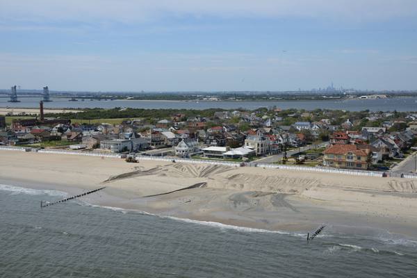
Community Board 14, which covers the Rockaway peninsula, was decimated by Sandy’s storm surge, not only from the ocean side, but also from the Jamaica Bay side.
Board Chair Doris Orr described the devastation in her survey response: “On the ocean side of the peninsula, west of Beach 86th street (where there are no rock jetties), [there is] complete devastation - all homes flooded anywhere from 4 ft to 12 ft. Wave force destroyed all ocean front homes [and the] … boardwalk.”
Orr added, “on [the] Bay side, all homes- [the] entire length of peninsula- major flooding. More than 150 homes burned to ground and 400 homes off their foundations or washed into Jamaica Bay.”
Orr also said in her response that CB14 did not feel the community’s voice was being heard by the city on the issue of climate resilience.
Nonetheless, CB14 District Manager Jonathan Gaska said he is cautiously optimistic that the shoreline (Rockaway Beach) will be protected in a series of steps taken by the city over the next several years. He said that the city replaced the seawall on the beachside, and questioned how it would weather another storm like Sandy.
However, Gaska’s bigger concern is that the city and the Army Corps of Engineers will ignore the bayside. He said there was extensive flooding from Jamaica Bay into the area during Sandy.
“You know when the mayor came out with that report, he spoke of putting up these temporary metal kind of water walls to protect from storm surge [on the shore side]. You know something like that needs to be looked at in large factions around the bay,” Gaska pointed out.
“So we're a little concerned — we're a lot concerned actually about the lack of concrete measures to protect our communities that face the bay,” he said.
Gaska said that on the bayside there are only sections of little seawalls (which they call baywalls) and they can easily collapse during a surge. Even though the mayor’s report does talk about raising and repairing bulkheads in some sections, primarily Belle Harbor, Gaska said that it is not enough.
Gaska said his community has done everything they can to alert the city of their needs.“Well, we've commented, we've testified. The community, different neighborhoods have done the same. We've done it through our elected officials. … So I think it's clear unless you've lived under a rock … you know what the issues are here and what the concerns are,” Gaska said.
He added that some homeowners in the area are not going to be able to afford the new flood insurance rates and have decided to leave, which could impact the district economically, an issue that he said has not been addressed by the city. Questions on flood insurance were raised by several boards, including Queens CB10 in Howard Beach and Brooklyn CB15 in Sheepshead Bay.
A spokesman for the city, Jake Goldman, said that while flood insurance has been managed by the federal government, the city was examining the issue closely because of the impact of redrawn flood maps and new federal legislation. “This [the cost] could decimate neighborhoods,” he said. The city would be releasing a study on the issue and suggestions on how to mitigate rising insurance costs, he said.
“Thirty thousand more people will be added to the floodplains,” Goldman said. “We will be working closely with communities once we have the facts.”
We’ll look more closely at the challenges of planning for climate change at the community-based level in Friday’s story.
Special Report: Are The City's Most Storm-Vulnerable Communities Being Heard?
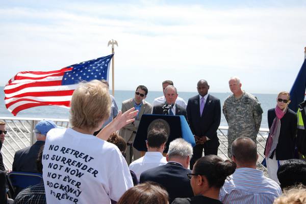
On Manhattan’s Lower East Side, residents worry about how to prevent the elderly and disabled from being trapped in their apartments during the next hurricane — the city, meanwhile, is proposing a large-scale housing and commercial development along the East River.
In the Rockaways, residents say that the danger of flooding from future storm surges on the peninsula’s Jamaica Bay side needs immediate attention — the city, though, is focused on oceanside beach reconstruction.
Along the Brooklyn waterfront, small businesses that spent weeks digging out from mud and debris left behind by Sandy say they need assistance with storm-proofing their facilities — not loans, as the city suggests.
Nearly a year after Superstorm Sandy, are City Hall and the city’s neighborhoods on the same page when it comes to planning for climate change and the possibility of another catastrophic storm?
{sidebar id=25}
A two-month investigation revealed striking disconnects in communication between the city and some community boards — the frontline of local government — as New Yorkers face the colossal task of remaking the metropolis to be more resilient to extreme weather caused by climate change.
While the city has proposed ambitious, even groundbreaking, plans to address the challenges, there is a clear gap between what some communities and the current administration perceive to be needs and priorities.
In response to our findings, current and former city officials involved with long-term planning said that while the input of the public had been sought after Sandy, and community boards in particular engaged on the local level, the process had been far from perfect. “The city has been invited by community boards in impacted areas to brief them on the resiliency progress and we will continue to do so at every available opportunity,” said Daniel Zarrilli, the city’s resilience director.
Seth Pinsky, who oversaw an initiative that sought to find ways to make the city more resilient in the wake of Hurricane Sandy, suggested that the dissatisfaction on the part of some of the community boards was unsurprising. “You’re not going to get 100 percent satisfaction from 100 percent of the people in 100 percent of the neighborhoods,” he said.
As part of the investigation, a team of reporters for Gotham Gazette and AdaptNY, a digital news platform for the debate around adapting to climate change, surveyed and conducted lengthy interviews with representatives from 11 of the 18 community districts found in five areas identified by the city as having been hardest hit by last October’s superstorm.
The investigation by Gotham Gazette and AdaptNY also found:
• A high level of frustration with the city on the part of some boards. Only five of those 11 boards said they were communicating well with the city on climate change resiliency issues despite the city’s intense focus on the topic and the level of damage suffered in the areas.
And more than half of the boards surveyed said their community’s voice was either not being heard well, or not heard at all, by the city on the question of climate resilience.
An even higher proportion — two-thirds or six out of nine boards surveyed — said the city and their community were not working together well towards local climate resilience needs. And only about half of the boards surveyed said they’d had frequent meetings or other kinds of communications with the city about this pressing problem.
The frustration was clear from one response by Queens Community Board 14, which covers the Rockaways. “[The] city [is] doing what THEY want regardless of what the local community feels,” Chair Dolores Orr said.
• Faulty communication between some of the boards and the city has led to a sense that steps are not being taken fast enough to rebuild in anticipation of more extreme weather.
“The mayor’s office is talking. The governor’s office is talking. Army Corps is talking. But no one’s lifted a hand. Nothing’s been done yet that I can think of. Nothing,” complained Theresa Scavo, chair of Brooklyn Community Board 15, which covers waterfront areas like Sheepshead Bay and Manhattan Beach.
Community Board 6 on Manhattan’s East Side, which is in the three flood zones most likely to be affected in the next Sandy-like storm, said in its response to the survey: “There are serious issues that need to be addressed immediately before the next storm season."
• At the same time, other community boards in some of the city’s most vulnerable areas seem unwilling to take on the issue of climate change planning altogether.
As District Manager Robert Perris said, “The environment committee of [Brooklyn] Community Board 2 gives almost no thought to the environment. I am sure few of them have even read media reports about the mayor’s resilience strategies.”
Clearly, communication between the city and residents in vulnerable areas has occurred on multiple pathways since Sandy. The City Council, community groups, and other institutions played an important role in bringing the feedback of local residents back to City Hall.
But New York City’s community boards, all-volunteer bodies of local government systematically located throughout the five boroughs, could — in theory, at least — provide an important way to look at city-community dialogue, and decision-making, related to climate change. Community boards are the city’s most localized form of representative government, and some have environmental committees (although others do not).
Community Boards: An Explainer
While the boards are an integral part of certain city processes, for instance with land-use and zoning review, overall they are relatively powerless advisory entities with non-binding votes (See sidebar backgrounder on community boards).
Yet the city does not seem to envision a direct planning role for the community boards in developing its climate change and resiliency strategies. Zarrilli said that the boards, along with local elected officials, should take a “leading role in providing feedback on community priorities and impacts of the plans ... especially as it pertains to the public review process surrounding specific projects.”
The city said that it also established two task forces with representation from community board members and has ongoing conversations with them through the Community Affairs Unit.
A Plan To Protect the City
Last winter, less than two months after Sandy, Mayor Michael Bloomberg described the storm as “the worst natural disaster ever to hit New York City,” and called for the city to undertake an expansive and expensive effort to examine ways to adapt to possible climate change impacts such as storm surges, inland flooding, high winds and other extreme weather-related issues.
The Special Initiative for Rebuilding and Resiliency, or SIRR, was charged “with producing a plan to provide additional protection for New York’s infrastructure, buildings, and communities from the impacts of climate change.”
The result, in June, was outlined in a 400-plus-page report, “A Stronger, More Resilient New York,” which extensively documented the physical damage wrought by Sandy and provided a “roadmap” for rebuilding.
The SIRR report includes summaries of the “priorities” indicated by residents of five target areas: Lower Manhattan, the Brooklyn-Queens waterfront, southern Brooklyn (which includes Coney Island), southern Queens (essentially the Rockaways and communities along Jamaica Bay), and the eastern and southern shores of Staten Island.
Those five areas, the city said, “ultimately suffered the greatest lingering physical damage” from Sandy. Home to 683,000 residents and nearly 42,000 businesses, they are all essentially waterfront communities, sitting along New York Harbor, the Atlantic coastline and Jamaica Bay, or inland bodies, such as Newtown and Coney Island creeks, and the Gowanus Canal.
The city’s scientists say that these areas and others will steadily become more and more vulnerable to future storms and sea level rise.
Projections released by the New York City Panel on Climate Change earlier this year state that by the 2050s, sea level rise is projected to rise 11 to 24 inches (middle range) and 31 inches (high estimate). The panel noted that, if using its high estimate for sea level rise, “today’s 1-in-100 year flood may occur approximately 5 times more often by the 2050’s.” The panel also projects that the number of “intense” hurricanes in the North Atlantic Basin will also likely increase.
Pinsky, who served as the head of the city’s Economic Development Corp. before departing for the private sector in July, was charged with overseeing SIRR, and said that “public input was a very important part of our process.”
The city’s community engagement effort included meeting with “interest groups,” such as faith-based organizations and labor unions, as well as affected neighborhoods. Public workshops were attended by more than 1,000 New Yorkers, including a number of community board members, Pinsky said.
He said the SIRR team met with principles and staff of over 65 elected offices and over 20 community boards on a regular basis.
Explained Pinsky: “We were not only able to achieve the goals that we set out of frequent detailed conversations with elected officials and the public. But the quality of the [city’s rebuilding and climate resiliency] plan was significantly enhanced by the feedback we received.” He added that feedback was incorporated when it was “consistent with our principles, realistic and achievable.”
He pointed to public opinion polls that show community satisfaction with the SIRR plan, including a June 27 Quinnipiac poll finding that 74 percent of New Yorkers and 82 percent of Staten Islanders support it. He said there was a positive response from the environmental community but conceded that there will be people who dislike certain elements.
The View From The City’s Neighborhoods
But, as the extensive SIRR report was released, reaction to the city’s feedback mechanism and workshops was mixed.
On the one hand, there were glowing remarks. “The information just flowed from the city ... there was truly an open ear and they wanted to hear the impact,” said Marnee Elias-Pavia, district manager of Brooklyn Board 11, which includes Bensonhurst and Gravesend.
But District Manager Robert Perris of Brooklyn Board 2 had a different view. “We were invited to public forums where we can weigh in on the SIRR report. … I attended a few sessions but I felt like they just presented their ideas to us, but didn't really seem open to our comments,” he said.
“A lot of what was discussed was technical and difficult to follow,” added Tamara Greenfield, who attended the city’s SIRR report meetings with other members of Manhattan Community Board 3.
While the main damage sustained by Brooklyn Board 11 was the flooding of the Belt Parkway, both Brooklyn Board 2 and Manhattan Board 3 experienced major flooding directly in their communities because of the East River storm surge during Sandy. The surge flooded sections of Manhattan Board 3, which covers the Lower East Side, causing building damage and power outages. This led to the entrapment of elderly and other homebound residents, especially in high-rise buildings, said board members. Sections of Brooklyn Board 2, like DUMBO and the Brooklyn Navy Yard, also experienced five-feet of flooding and power outages.
Some have suggested that greater community involvement in climate change planning should have been more a part of the SIRR mix. An analysis of the SIRR report by the Sandy Regional Assembly, which was convened by 200 community, labor and civic groups from the city’s most heavily impacted areas, argued that more neighborhood-led policy development should have been a SIRR recommendation.
“The SIRR’s analysis of community capacity should not have been limited to “outreach” activities. Instead, it should have included community-based planning and research capacity,” the assembly wrote in July.
In a number of cases, the local community boards did report that they felt the city has been listening.
An example of positive feedback on city–community board interactions came from the tip of Lower Manhattan. Catherine Hughes, chairwoman for Manhattan Community Board 1, said she believes that the voice of her community is being heard in city government, and that the city and community board are working together to adapt to climate change.
According to Hughes, CB1 had several meetings with city officials prior to the release of the mayor’s SIRR report and said that some of its recommendations have been implemented.
Despite that, Hughes remains concerned about flooding in the tunnels, the major arteries that connect lower Manhattan to the outer boroughs.
“I would like to know what are they doing to protect those major underpasses,” she said. Hughes added, “We’re in the middle of the hurricane season and we want to know what is in place for now.”
CLARIFICATION: Gotham Gazette reported that the city is proposing a "large-scale luxury housing development along the East River." However, it remains undetermined how much of the housing will be high-end or "affordable", and there will also be commercial opportunities.
Coming this Wednesday in part two of our three-part series: A closer look at community boards in the city’s most vulnerable areas, and how well the citywide climate resilience process has worked for them.

