Preparing for the Great New York Earthquake
Most New Yorkers probably view the idea of a major earthquake hitting New York City as a plot device for a second-rate disaster movie. In a city where people worry about so much -- stock market crashes, flooding, a terrorist attack -- earthquakes, at least, do not have to be on the agenda.
A recent report by leading seismologists associated with Columbia University, though, may change that. The report concludes a serious quake is likely to hit the area.
The implication of this finding has yet to be examined. Although earthquakes are uncommon in the area relative to other parts of the world like California and Japan, the size and density of New York City puts it at a higher risk of damage. The type of earthquake most likely to occur here would mean that even a fairly small event could have a big impact.
"The issue with earthquakes in this region is that they tend to be shallow and close to the surface," explains Leonardo Seeber, a coauthor of the report. "That means objects at the surface are closer to the source. And that means even small earthquakes can be damaging."
The past two decades have seen an increase in discussions about how to deal with earthquakes here. The most recent debate has revolved around the Indian Point nuclear power plant, in Buchanan, N.Y., a 30-mile drive north of the Bronx, and whether its nuclear reactors could withstand an earthquake. Closer to home, the city adopted new codes for its buildings even before the Lamont report, and the Port Authority and other agencies have retrofitted some buildings. Is this enough or does more need to be done? On the other hand, is the risk of an earthquake remote enough that public resources would be better spent addressing more immediate -- and more likely -- concerns?
Assessing the Risk
The report by scientists from the Lamont-Doherty Earth Observatory at Columbia University at summarizes decades of information on earthquakes in the area gleaned from a network of seismic instruments, studies of earthquakes from previous centuries through archival material like newspaper accounts and examination of fault lines.
The city can expect a magnitude 5 quake, which is strong enough to cause damage, once every 100 years, according to the report. (Magnitude is a measure of the energy released at the source of an earthquake.) The scientists also calculate that a magnitude 6, which is 10 times larger, has a 7 percent chance of happening once every 50 years and a magnitude 7 quake, 100 times larger, a 1.5 percent chance. Nobody knows the last time New York experienced quakes as large as a 6 or 7, although if once occurred it must have taken place before 1677, since geologists have reviewed data as far back as that year.
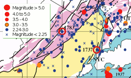
The last magnitude 5 earthquake in New York City hit in 1884, and it occurred off the coast of Rockaway Beach. Similar earthquakes occurred in 1737 and 1783.
By the time of the 1884 quake, New York was already a world class city, according to Kenneth Jackson, editor of The Encyclopedia of New York City."In Manhattan," Jackson said, "New York would have been characterized by very dense development. There was very little grass."
A number of 8 to 10 story buildings graced the city, and "in world terms, that's enormous," according to Jackson. The city already boasted the world's most extensive transportation network, with trolleys, elevated trains and the Brooklyn Bridge, and the best water system in the country. Thomas Edison had opened the Pearl Street power plant two years earlier.
All of this infrastructure withstood the quake fairly well. A number of chimneys crumbled and windows broke, but not much other damage occurred. Indeed, the New York Times reported that people on the Brooklyn Bridge could not tell the rumble was caused by anything more than the cable car that ran along the span.
Risks at Indian Point
As dense as the city was then though, New York has grown up and out in the 124 years since. Also, today's metropolis poses some hazards few, if any people imagined in 1884.
In one of their major findings, the Lamont scientists identified a new fault line less than a mile from Indian Point. That is in addition to the already identified Ramapo fault a couple of miles from the plant. This is seen as significant because earthquakes occur at faults and are the most powerful near them.
This does not represent the first time people have raised concerns about earthquakes near Indian Point. A couple of years after the licenses were approved for Indian Point 2 in 1973 and Indian Point 3 in 1975, the state appealed to the Atomic Safety and Licensing Appeal Panel over seismic issues. The appeal was dismissed in 1976, but Michael Farrar, one of three members on the panel, dissented from his colleagues.
He thought the commission had not required the plant to be able to withstand the vibration that could occur during an earthquake. "I believe that an effort should be made to ascertain the maximum effective acceleration in some other, rational, manner," Farrar wrote in his dissenting opinion. (Acceleration measures how quickly ground shaking speeds up.)
Con Edison, the plants' operator at the time, agreed to set up seismic monitoring instruments in the area and develop geologic surveys. The Lamont study was able to locate the new fault line as a result of those instruments.
Ironically, though, while scientists can use the data to issue reports -- the federal Nuclear Regulatory Commission cannot use it to determine whether the plant should have its license renewed. The Nuclear Regulatory Commission only considers the threat of earthquakes or terrorism during initial licensing hearings and does not revisit the issue during relicensing.
Lynn Sykes, lead author of the Lamont report who was also involved in the Indian Point licensing hearings, disputes that policy. The new information, he said, should be considered -- "especially when considering a 20 year license renewal."
The state agrees. Last year, Attorney General Andrew Cuomo began reaching out to other attorneys general to help convince the commission to include these risks during the hearings.
Cuomo and the state Department of Environmental Conservation delivered a 312-page petition to the commission that included reasons why earthquakes posed a risk to the power plants. The petition raised three major concerns regarding Indian Point:
- The seismic analysis for Indian Point plants 2 and 3 did not consider decommissioned Indian Point 1. The state is worried that something could fall from that plant and damage the others.
- The plant operators have not updated the facilities to address 20 years of new seismic data in the area.
- The state contends that Entergy, the plant's operator, has not been forthcoming. "It is not possible to verify either what improvements have been made to [Indian Point] or even to determine what improvements applicant alleges have been implemented," the petition stated.
A spokesperson for Entergy told the New York Times that the plants are safe from earthquakes and are designed to withstand a magnitude 6 quake.
Lamont's Sykes thinks the spokesperson must have been mistaken. "He seems to have confused the magnitude scale with intensity scale," Sykes suggests. He points out that the plants are designed to withstand an event on the intensity scale of VII, which equals a magnitude of 5 or slightly higher in the region. (Intensity measures the effects on people and structures.) A magnitude 6 quake, in Sykes opinion, would indeed cause damage to the plant.
The two reactors at Indian Point generate about 10 percent of the state's electricity. Since that power is sent out into a grid, it isn't known how much the plant provides for New York City. Any abrupt closing of the plant -- either because of damage or a withdrawal of the operating license -- would require an "unprecedented level of cooperation among government leaders and agencies," to replace its capacity, according to a 2006 report by the National Academies' National Research Council, a private, nonprofit institution chartered by Congress.
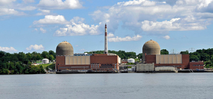
Beyond the loss of electricity, activists worry about possible threats to human health and safety from any earthquake at Indian Point. Some local officials have raised concerns that radioactive elements at the plant, such as tritium and strontium, could leak through fractures in bedrock and into the Hudson River. An earthquake could create larger fractures and, so they worry, greater leaks.
In 2007, an earthquake hit the area surrounding Japan's Kashiwazaki-Kariwa nuclear power plant, the world's largest. The International Atomic Energy Agency determined "there was no significant damage to the parts of the plant important to safety," from the quake. According to the agency, "The four reactors in operation at the time in the seven-unit complex shut down safely and there was a very small radioactive release well below public health and environmental safety limits." The plant, however, remains closed.
Shaking the Streets
A quake near Indian Point would clearly have repercussions for New York City. But what if an earthquake hit one of the five boroughs?
In 2003, public and private officials, under the banner of the New York City Area Consortium for Earthquake Loss Mitigation, released a study of what would happen if a quake hit the metropolitan area today. Much of the report focused on building damage in Manhattan. It used the location of the 1884 quake, off the coast of Rockaway Beach, as its modern muse.
If a quake so serious that it is expected to occur once every 2,500 years took place off Rockaway, the consortium estimated it would cause $11.5 billion in damage to buildings in Manhattan. About half of that would result from damage to residential buildings. Even a moderate magnitude 5 earthquake would create an estimated 88,000 tons of debris (10,000 truckloads), which is 136 times the garbage cleared in Manhattan on an average day, they found.
The report does not estimate possible death and injury for New York City alone. But it said that, in the tri-state area as a whole, a magnitude 5 quake could result in a couple of dozen deaths, and a magnitude 7 would kill more than 6,500 people.
Ultimately, the consortium decided retrofitting all of the city's buildings to prepare them for an earthquake would be "impractical and economically unrealistic," and stressed the importance of identifying the most vulnerable areas of the city.
Unreinforced brick buildings, which are the most common type of building in Manhattan, are the most vulnerable to earthquakes because they do not absorb motion as well as more flexible wood and steel buildings. Structures built on soft soil are more also prone to risk since it amplifies ground shaking and has the potential to liquefy during a quake.
This makes the Upper East Side the most vulnerable area of Manhattan, according to the consortium report. Because of the soil type, the ground there during a magnitude 7 quake would shake at twice the acceleration of that in the Financial District. Chinatown faces considerable greater risk for the same reasons.
The city's Office of Emergency Management agency does offer safety tips for earthquakes. It advises people to identify safe places in their homes, where they can stay until the shaking stops, The agency recommends hiding under heavy furniture and away from windows and other objects that could fall.
A special unit called New York Task Force 1 is trained to find victims trapped in rubble. The Office of Emergency Management holds annual training events for the unit.
The Buildings Department created its first seismic code in 1995. More recently, the city and state have adopted the International Building Code (which ironically is a national standard) and all its earthquake standards. The "international" code requires that buildings be prepared for the 2,500-year worst-case scenario.
Transportation Disruptions
With the state's adoption of stricter codes in 2003, the Port Authority went back and assessed its facilities that were built before the adoption of the code, including bridges, bus terminals and the approaches to its tunnels. The authority decided it did not have to replace any of this and that retrofitting it could be done at a reasonable cost.
The authority first focused on the approaches to bridges and tunnels because they are rigid and cannot sway with the earth's movement. It is upgrading the approaches to the George Washington Bridge and Lincoln Tunnel so they will be prepared for a worst-case scenario. The approaches to the Port Authority Bus Terminal on 42nd Street are being prepared to withstand two thirds of a worst-case scenario.
The terminal itself was retrofitted in 2007. Fifteen 80-foot tall supports were added to the outside of the structure.
A number of the city's bridges could be easily retrofitted as well "in an economical and practical manner," according to a study of three bridges by the consulting firm Parsons Brinckerhoff. Those bridges include the 102nd Street Bridge in Queens, and the 145th Street and Macombs Dam bridges, which span the Harlem River. To upgrade the 155th Street Viaduct, the city will strengthen its foundation and strengthen its steel columns and floor beams.
The city plans upgrades for the viaduct and the Madison Avenue bridge in 2010. The 2008 10-year capital strategy for the city includes $596 million for the seismic retrofitting of the four East River bridges, which is planned to begin in 2013. But that commitment has fluctuated over the years. In 2004, it was $833 million.
For its part, New York City Transit generally is not considering retrofitting its above ground or underground structures, according to a report presented at the American Society of Civil Engineers in 2004. New facilities, like the Second Avenue Subway and the Fulton Transit Center will be built to new, tougher standards.
Underground infrastructure, such as subway tunnels, electricity systems and sewers are generally safer from earthquakes than above ground facilities. But secondary effects from quakes, like falling debris and liquefied soil, could damage these structures.
Age and location -- as with buildings -- also add to vulnerability. "This stuff was laid years ago," said Rae Zimmerman, professor of planning and public administration at New York University. "A lot of our transit infrastructure and water pipes are not flexible and a lot of the city is on sandy soil." Most of Lower Manhattan, for example, is made up of such soil.
She also stresses the need for redundancy, where if one pipe or track went down, there would be another way to go. "The subway is beautiful in that respect," she said. "During 9/11, they were able to avoid broken tracks."
Setting Priorities
The city has not made preparing its infrastructure for an earthquake a top priority -- and some experts think that makes sense.
"On the policy side, earthquakes are a low priority," said Guy Nordenson, a civil engineer who was a major proponent of the city's original seismic code, "and I think that's a good thing." He believes there are more important risks, such as dealing with the effects of climate change.
"There are many hazards, and any of these hazards can be as devastating, if not more so, than earthquakes," agreed Mohamed Ettouney, who was also involved in writing the 1995 seismic code.
In fact, a recent field called multi-hazard engineering has emerged. It looks at the most efficient and economical way to prepare for hazards rather than preparing for all at once or addressing one hazard after the other. For example, while addressing one danger (say terrorism) identified as a priority, it makes sense to consider other threats that the government could prepare for at the same time (like earthquakes).
Scientists from Lamont-Doherty are also not urging anybody to rush to action in panic. Their report is meant to be a first step in a process that lays out potential hazards from earthquakes so that governments and businesses can make informed decisions about how to reduce risk.
"We now have a 300-year catalog of earthquakes that has been well calibrated" to estimate their size and location, said Sykes. "We also now have a 34-year study of data culled from Lamont's network of seismic instruments."
"Earthquake risk is not the highest priority in New York City, nor is dog-poop free sidewalks," Seeber recently commented. But, he added, both deserve appropriately rational responses.
Â
Climate Change Could Threaten a Green Willets Point
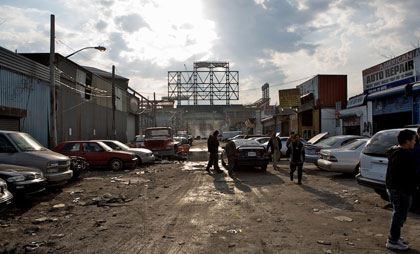
Adjacent to the Mets' new home at Citi Field, Willets Point houses the New York area's largest concentration of auto repair and service businesses, the nation's biggest distributor of Indian foods and several waste transfer facilities. All that could change dramatically, though, if the Bloomberg administration has its way and transforms the area into the city's first "green" neighborhood.
The mayor's proposal has raised the ire of local business owners and housing advocates, who decry the plan's use of eminent domain to seize the commercial property and contend that it does not include enough affordable housing. Those opponents turned out in full force on Wednesday at the City Planning Commission's public hearing on the project.
Small business owners and community activists waved signs condemning the use of eminent domain, while shouting "Willets Point is not for sale."
The commission is in the process of a 60-day review period on the project. It must make a decision by September 29. If approved, the City Council would then take over, making the ultimate up or down choice on the sprawling development. The outcome of that decision is anyone's guess, since a number of City Council members (including Councilmember Hiram Monserrate who represents the area) strenuously oppose the project.
Surprisingly, amid all the controversy swirling around Willets Point, very few have questioned whether the city's "first green neighborhood" will eventually be submerged by water.
Known as "the Iron Triangle," Willets Point is legendary for the vast potholes that punctuate its barely paved streets and its lack of a modern sewer system. Evidence of polychlorinated biphenyls (PCBs), heavy metals, pesticides, herbicides and rodenticides also have been found throughout the district. No one disagrees that the area is sorely in need of improvement. In fact, local business owners have lobbied the city for years to repair potholes and install an updated sewer system. But the city has maintained that because the area is located in a flood plain, it cannot install a sewer system with the current owners in place.
Then in 2007, city officials announced a long-awaited solution to the problems in Willets Point -- a $3 billion plan to seize 61 acres of the district, raze it, and construct a hotel, convention center, 5,500 units of housing (80 percent of which will be market-rate) and over 2 million square feet of office space, as well as restaurants, a movie theater and retail shops. Even more ambitiously, the city intends to transform Willets Point into New York City's "first green neighborhood," with trees, bike paths and parks, state-of-the-art energy efficient buildings, innovative water management (including the use of green roofs and "graywater systems") and public-transit oriented development. In short, the project fulfills many of the goals outlined in PlaNYC 2030.
The Opposition
But local business owners are not so optimistic about the transformation of Willets Point. On hearing about the plan, they immediately organized to protect their property from eminent domain. They filed a lawsuit accusing the city of "negligent, reckless and willful refusal" to provide infrastructure with the ultimate goal of declaring the area blighted, a condition that can trigger eminent domain. Instead, business owners want the city to fix existing infrastructure and revitalize the area without removing businesses. Many worry that moving to other parts of the city could jeopardize their businesses.
In April, 29 of 51 City Council members signed a letter demanding that the administration "stop the clock" on the land use -- or ULURP -- process to approve the plan. Initiated by Monserrate, the letter states, "We adamantly oppose moving forward with the current redevelopment plan for Willets Point. The plan is deeply flawed, and the opportunity for public consideration has been dangerously absent. We disagree with your decision to pursue ULURP certification for this project. As elected officials, we urge you to reconsider this plan and to engage in a more accessible and transparent process." This week another letter, saying they couldn't vote for the project as is, was sent to the commission with 32 members signed on.
City Council members might also question the administration's definition of "sustainable." Willets Point sits in a flood plain and is close to Flushing Creek and Flushing Bay. Climate experts warn that increased storms and flooding due to climate change pose a potentially dire future for waterfront projects such as Willets Point. Does sustainability end at the year 2030? For how many future generations is PlaNYC 2030 planning?
The Fill and The Flood
"Two of the greatest challenges [at Willets Point] are site contamination and site elevation," states the New York City Economic Development Corporation's Environmental Impact Statement. To address that problem, the city plans to install up to six feet of fill prior to site redevelopment.
The fill will be used to "cap" contamination at the site, sealing toxins underneath a mound of new dirt. The effectiveness of this method for containing contamination is debatable. Caps need to be carefully maintained against the effects of erosion, especially in low-lying areas. More significantly, a report by the Canada's Contaminated Sites Working Group maintains that capped areas are never suitable for further development as capping carries a risk of leakage. Again, low-lying areas close to waterways and estuaries magnify this risk.
"There are good, current and acceptable methods for evaluating these impacts, but the project sponsor has not considered any of them," says climate change expert Linda Sohl in a prepared statement released by the project's opponents. "Furthermore, all of lower Manhattan, including the World Trade Center site and most waterfront land in New York City is in the 100-year flood plain - for some reason the city is not concerned with elevating these areas with fill."
Her words raise concerns about whether six feet of fill is adequate. At less than 14 feet above sea level, Willets Point now lies well within the Federal Emergency Management Agency's designation for a 100-year floodplain -- an area with a 100 percent chance of flooding during a flood that has a 1 percent chance of occurring during any given year. Right now, FEMA's threshold for a floodplain is 14 feet above sea level. Six feet of fill raises Willets Point to between 14 and 17 feet above sea level -- not far from the federal threshold.
The International Panel on Climate Change predicts that East Coast sea levels will rise by one to three feet by the year 2100, depending on how well we reduce the greenhouse gas emissions that cause global warming. Certainly, a three-foot rise in sea level will not put Willets Point under water. The problem is that even a one-foot rise in sea level (the best case scenario) will likely double the frequency of coastal surging and related flooding. In other words, even if we reduce greenhouse gas emissions by 30 percent, the Union of Concerned Scientists predicts that by 2100, 100-year floods could occur an average of every 22 years. Moreover, researchers at Columbia University's Lamont-Doherty Earth Observatory warn that we will almost certainly see storm surges of more than 20 feet.
Economic Development Corporation officials maintain that the proposed elevations will protect the area from current and future threats of floods. Going a step further, they pledge to keep the area out of floodplain designations, should FEMA update them in the future, although they do not offer any specifics on how they would do that. Development corporation officials also stated that they would adhere to all governmental guidelines including those set by the Department of Buildings and the Department of Environmental Protection, especially as those guidelines shift in light of climate change. Of course, PlaNYC2030, itself, was designed in part to "create a strategic planning process to adapt to climate change impacts."
Beyond that, though, the plan hopes to limit climate change by reducing greenhouse gas emissions by 30 percent by the year 2030. As a result, building a whole new community -- even a sustainable one -- at Willets Point poses an apparent contradiction since constructing a new 50,000-square foot commercial building releases about the same amount of carbon into the atmosphere as driving a car 2.8 million miles.
"No matter how much green technology is employed in its design and construction, any new building represents a new impact on the environment," explains Richard Moe, president of the National Trust for Historic Preservation. At the same time, improving existing buildings and infrastructure almost always produces a lower level of emissions.
In the case of Willets Point, the development offers a particularly ironic twist. In seeking to build New York City's first "green" neighborhood, the city could instead add to global warming and endanger that very same community.
ÂFighting the Asian Long-Horned Beetle
Like a monster in a sci-fi movie, an invading black-and-white beetle with outsized striped antennae has the potential to undo the city's efforts to plant a million more trees. The Asian long-horned beetle could kill nearly half the city's hardwood trees and spell disaster for the Northeast's forests, parks officials say.
A tree-killing attack starts when the beetle chews holes in the bark of a tree to lay its eggs. The eggs hatch into larvae that bore into the heartwood, where they live and feed during the colder months before emerging as adults in the spring. The Asian long-horned beetle infests many different kinds of hardwoods, including all maple species, birch, horse chestnut, London plane, sycamore, poplar, willow, elm and ash.
It is believed that the beetle hitched a ride in wooden packing material shipped from China. The first New York sighting of the beetle was in Greenpoint, Brooklyn, in 1996. Since then, it has been found in all boroughs except the Bronx, as well as in Long Island and New Jersey. (A separate infestation discovered in Chicago in 1998 was recently declared eradicated by the U.S. Department of Agriculture.)
Attack on Staten Island
Last year, the invader made inroads into Staten Island for the first time, using Prall's Island, an uninhabited bird sanctuary in the Arthur Kill, as a stepping stone. At the time Parks Commissioner Adrian Benepe warned that, if left unchecked, the beetle "could wipe out .... half of the trees of Staten Island, which would completely change the character of the island."
Federal and state agencies and the city parks department quickly mounted an intensive control effort. Parks workers cut down and chipped nearly 3,000 trees on Prall's Island and 6,700 trees on the nearby Staten Island shore, destroying infested trees as well as any tree that could be a potential host within a half-mile radius.
In Staten Island and all the areas where the pest has been discovered, the state and federal agencies conduct year-round surveying for evidence of infestation; in the spring, insecticide is injected into potential host trees within a mile and a half of known infestations.
This past spring, a parks department restoration team began replanting new trees, shrubs and native plants on Prall's Island.
The eradication efforts appear to have halted the Asian long-horned beetle's advance in Staten Island, and so far this year no new infestations have been reported anywhere in New York City.
To prevent the inadvertent spread of the beetle, the parks department also provides free pick-up, chipping and disposal of residential wood waste in the four boroughs where the pest has been found.
The Government and the Public
In spite of the seriousness of the threat, federal funding to fight the beetle in New York City has been cut in recent years. For next year, Rep. Anthony Weiner is asking for $48 million for the federal beetle eradication program, $30 million of which would go to the city.
"New York City is the central point of infestation," Weiner said at a press conference earlier this year. But, he added, ""If we don't stop this, it won't be only a New York City problem."
Even if Washington did step up its support, the parks department would be unable to survey the city's more than 5 million trees in streets, parks and yards. As a result, the eradication effort depends on the public. Anyone who suspects an infestation should call the toll-free number 1-877-STOPALB or 311.
The beetle is one to one-and-a-half inches long, with a shiny black body, white spots and very long, black-and-white striped antennae. Telltale evidence of an infestation includes dime or pencil-sized holes, usually in a tree's upper trunk or branches, and piles of frass (sawdust and insect waste) at the base of a tree or where branches meet the trunk.
For more information, check the Web sites of the New York City parks department and U.S. Department of Agriculture's Animal and Plant Health Inspection Service.
 Anne Schwartz, in charge of the parks topic page since its inception in 1999, is a journalist who specializes in environmental issues.Â


