Protecting The Park In The Parkway
Snow can make parks look like heaven – and roads feel like hell. But it was a previous snowstorm that made it clear how much New York City’s parkways — which are both parks and roads — are in a weird kind of limbo.
|
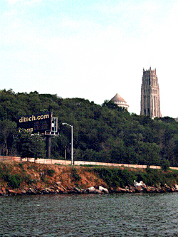
Scenic byways prevent the proliferation of billboards |
Mayor John Lindsay had reorganized the city’s agencies so that, when the blizzard of February, 1969 hit, it was unclear whose responsibility it was to clear the parkways – and they remained unplowed for three days, paralyzing the city.
No mayor will ever make such a politically costly mistake again; the Department of Sanitation very clearly now has the job of removing snow from the parkways.
But a complicated bureaucratic system remains in place, which is causing real damage year-round.
Last year, a great stone wall in Washington Heights collapsed onto the Henry Hudson Parkway, the most visible evidence of the sinking fortunes of America’s first and once-glorious urban parkway. Last month, a deal to restore the parkway collapsed as well. Even the prospect of millions of dollars in new federal funds for the city was not enough to overcome a system set in place that values roads over parks.
Many people may hear “parkway” and just think “highway.” Others realize that a parkway is in fact a road through a park. But a parkway is not just the road itself; it is also the parkland on either side. New York City’s parkways, a monumental public works project achieved jointly in the 1930’s by FDR, LaGuardia and Robert Moses, were designed as the most extensive urban park system in the world. The Henry Hudson Parkway alone, which runs from West 72nd Street in Manhattan to the top of the Bronx, links together four major parks, nine smaller ones, countless pocket parks and great swaths of untouched nature. Even now the beauty and coherence of the vision is clear to anybody who takes the time to notice—not just the stunning natural and manmade features revealed with each curve and dip of the road, but the details that highlight the character of each section: art deco and rustic wooden guard rails, cultivated wilderness, esplanades for promenading and trails for meandering …and lovely stone walls.
It becomes harder and harder, though, to miss the damage. Concrete jersey barriers cover miles of stone walls and steel hairnets cover natural rock outcrops. Signs and billboards clutter the stone bridges of the Bronx and the skyline of Manhattan.
If that’s the motorist’s experience of the city, the resident’s is even sadder. Pedestrian tunnels and stairs that once led to the waterfront are abandoned. The expressway aesthetic spills over to neighborhoods. Huge parkway entrance signs loom over quiet streets in Riverdale. Harlem residents look out at billboards instead of the river.
Five years ago, I was one of the concerned residents who formed the Henry Hudson Parkway Task Force to reverse its fate. The way we realized this could happen is by getting the state government to agree to designate the parkway a Scenic Byway, under a special program created in 1992 to preserve the nation’s most beautiful roads. Scenic Byways are eligible for special federal funds—and not just transportation funds. When the 8.2 mile Pasadena Freeway (also known as the Arroyo Seco Parkway) was designated a Scenic Byway a few years ago, its state transportation department received a billion dollars in federal environmental funds to restore its landscape and bridges.
The New York State Department of Transportation, which administers the Scenic Byways Program, was enthusiastic about the Henry Hudson Parkway being the city’s first candidate. Besides its historic credentials, the parkway had acquired new importance. It is the site of the Hudson River Valley Greenway, the walking and bicycle trail that will eventually go from Battery Park to Saratoga, New York. Since the city and state are both pouring millions of dollars into building the greenway and revitalizing Manhattan’s west side waterfront, it made sense to include the parkway in the plan.
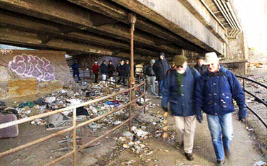
An example of paths and stairways under the parkways that are neglected (south of the George Washington Bridge).
It leads to the beautiful Ft. Washington Park.
But the application to make the Henry Hudson Parkway an official Scenic Byway was withdrawn. The reasons why are not known to the public: Though the agencies that make these decisions are public, they deliberate in secret.
What is known is that, like all of the city’s parkways, the Henry Hudson is an entanglement of jurisdictions. Decisions about its future are determined by a combination of agencies that meet together as the New York Metropolitan Transportation Council, which acts as the official regional planning body. The most important agencies within that body are the city's and state's transportation agencies. The most irrelevant agency is the city's Department of Parks and Recreation. Even though the parks department is officially a co-owner of the city’s parkways, it is not a member of the transportation council, nor is it even part of its advisory board. It has the smallest budget and the least political clout. Even if the parks department were part of the transportation council, however, it might not make a difference because the council is organized to protect the fiefdom of each member -- a rule requiring "unanimous consensus" gives each member a veto.
So, apparently, at least one of the transportation agencies involved in the New York Metropolitan Transportation Council got cold feet about the parks-oriented requirements of a Scenic Byways designation.
|
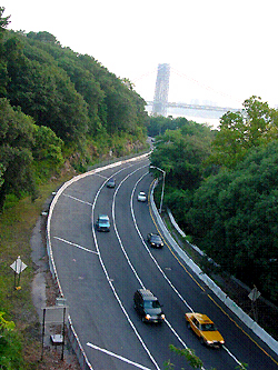
Parkways are designed to conform to the natural topography. Curves like this are what provide the sequence of stunning views. Unfortunately they are irresistible “straightening” projects for transportation departments in the name of “uniform [higher] speed limits” |
A scenic byway is about design guidelines. One can address the problem of graffiti in a parkway by painstakingly removing the graffiti and maintaining the beauty of the stone wall, or by quickly painting over it. One can mow the daffodils in a field so that they never come up again – or one can mow the field after it has become fallow, and keep the daffodils spreading for the next 20 years. To preservationists and parks enthusiasts, how one takes care of graffiti or daffodils makes a huge difference. But efficiency might be the by-word to those shortsighted enough to look at the parkway only as a means of transportation.
The city Department of Transportation may not want to have to keep the kind of wooden guide rails that are used along the Northern Parkway in Long Island or the Merritt Parkway in Connecticut (both scenic byways). It has its preferred way to protect stone parapets on the city's bridges -- with jersey barriers topped with chain link. The problem is compounded by the entanglement of jurisdictions. What one agency builds, another maintains. Each government agency is jointly and severally liable; even individual engineers can be held liable for projects they sign. The consequence is a hodgepodge of defensive design -- overbuilt and overpriced.
Fifty years have passed since the enactment of the 1956 Federal Aid Highway Act, the nation’s interstate highway system has been fully built for a decade, and our auto companies are now in open retreat. Yet none of this seems to have loosened the grip of the highway builders over the design of New York City. Having a metropolitan planning organization was supposed to stop the city from being strong-armed by the state transportation agency. Instead it is strong-armed by four transportation agencies and authorities, each fiercely protective of its prerogatives.
The scenic byway plan couldn’t have been derailed at a worse time. Both the new New York State Transportation Bond Act and the Federal Transportation Bill contain substantial funding for the parkway. Some of the money will be used to enhance the parks and waterfront. But with no plan in place, and no declared attention to the aesthetics, much of the money may well be spent in ways that undermine the park part of the parkway.
Hilary Hinds Kitasei is a free-lance writer and founder of the Henry Hudson Parkway Task Force Â
Parkstat To Fight Crime
The murder in Inwood Hill Park of Juilliard drama student Sarah Fox, who was killed in May 2004 while she was out jogging, had a chilling effect on residents’ use of the park. Tamara Ewoldt, who has lived near and run in the park for 15 years, stopped going there alone and organized a neighborhood runners’ group so people could run together.
Last July, another female jogger was assaulted in the park, escaping with injuries. Ewoldt and other residents, who want the park to be patrolled more effectively, had trouble getting information about the attack. “It’s important that local people have information about our park,” she said, “so that we can decide how we use it safely, and whether we use it at all.”
The only park for which crime statistics are available is Central Park, which has its own precinct. Compstat, the city’s highly regarded system for reporting, mapping and analyzing crime, does not identify crimes in parks. Parks Commissioner Adrian Benepe says that the parks, like the city as a whole, are safer than ever. But when people hear about crimes from the headlines, they feel uneasy about the places they go to play, exercise, and unwind -- the very places they feel most vulnerable.
A recently enacted law requiring the police to report felonies that occur in the parks will begin to fill the information void and may help the police and community better fight crime. “From now on when it comes to crimes in the parks, New Yorkers will no longer be left in the dark,” said Councilmember Peter Vallone, Jr., chair of the council’s public safety committee, who introduced the legislation with Councilmember Joseph Addabbo.
On signing the bill, Mayor Michael Bloomberg said, “This measure will continue the Administration’s commitment to open and transparent government.” The law fits with a growing trend for cities to collect, analyze, and make data publicly available, and to use it to hold managers accountable for improving city services.
Because of the technical difficulties and extra work involved, the police department initially was very reluctant to report crime in parks, as they do for the transit system and housing projects. It took two long, hard years of negotiations, led by Vallone, to reach a compromise acceptable to the police, the mayor, the council, and park advocates. The agreement phases in the reporting requirement over three years.
To begin with, the police department will provide data on all major felony crime complaints in 20 of the city’s large parks in its quarterly reports to the City Council, which can then make it available to the public. The 20 parks are being selected in cooperation with the parks department, but will likely include Inwood Hill Park. Eventually, all parks one acre or larger will be included.
The new measure has been called Parkstat, which is confusing because the parks department uses the same term to refer to its system for rating and improving park conditions.
The key to the effectiveness of the new law will be training police officers to more accurately report crimes that occur in parks. Under Compstat, the location of a crime is indicated using the nearest street address. Before, officers filling out a report had the option of reporting that the crime occurred in a park. The specific park was not named. There was no indication of whether the crime actually occurred in the park or whether the suspect was simply arrested there. Vallone said, “We have a commitment that they will improve their reporting methods.”
The parks department already uses police department crime data, running the information through the filters on its computerized mapping system to try and identify the specific parks, said Liam Kavanagh, first deputy commissioner of the parks department. They use the information internally, to coordinate their efforts with police precincts and make sure park staff is aware of criminal activity. But the information is incomplete and not available to the public. “I don’t think simply reporting on the basis of parks will in itself lead to a dramatic reduction in crime, but more information is better,” said Kavanagh. “I think it’s going to show how safe parks really are in relation to serious crime.”
Paul Browne, deputy commissioner of public information for the police department, said, “Time will tell whether it reveals any particular advantage.” He cautioned that crime rates need to be considered within the context of how many people use the park. Parks that have more visitors have more incidents of crime.
Although the police department handles serious crimes in the parks, the parks department has its own Parks Enforcement Patrol, which enforces park rules and issues summonses for offenses ranging from littering and climbing trees to defacing park property and disorderly conduct. PEP officers don’t carry guns, but their presence in the park is a deterrent to crime. According to Kavanagh, funding increases in last year’s budget allowed the department to add 60 new PEP officers, bringing the citywide total to 154 (although several dozen are assigned to recreation centers and training and are not patrolling). Even so, with more than 1,700 parks, playgrounds, and other facilities in the parks system, PEP officers are spread thin.
Park advocates hope that the crime data will shine a spotlight on parks or areas that are problematic and help focus resources where they are needed. In addition, said Christian DiPalermo, executive director of New Yorkers for Parks (www.ny4p.org), the citywide parks advocacy group, “The more people know the more they help the cops to deter crime.”
“The data could be used to help park managers learn what is working in one park that could be used in another,” he added. On the flip side, a sensational crime with a lot of coverage in the press can discourage people from using a park that is actually very safe, he said. “Tracking gives you perspective.”
 Anne Schwartz, in charge of the parks topic page since its inception in 1999, is a journalist who specializes in environmental issues.Â
Turning The High Line Elevated Railroad Into An Unconventional Park
In one of his last acts in office, Mayor Rudy Giuliani approved the demolition of the High Line, an abandoned elevated freight railroad running through Chelsea and the West Village. The owners of property shadowed by the hulking structure wanted it torn down. The idea of reinventing the tracks as a public open space, proposed by a grassroots group called Friends of the High Line, was a fantasy that few people gave any chance of success.
Fast forward three years. This October, the city announced the selection of a design team to make the track a public promenade, as well as the dedication of $43 million to the project, which has an estimated total cost of between $60 and $100 million. The State of New York and CSX Transportation, the railroad that owns the line, joined the city in petitioning the federal Surface Transportation Board to rail-bankthe line, which would transfer the easement to the city and allow its use as public space. If all goes as planned, construction will begin next fall. Against all odds, a crazy and impractical-seeming idea is rapidly becoming a reality.
The High Line was built in the 1930s to serve the refrigerated meat and dairy warehouses of the West Side, taking dangerous freight traffic off Tenth Avenue. Part of the line was torn down in the 1960s, and the remaining segment, from Gansevoort to 34th Street, was taken out of service in 1980. It was mostly forgotten, except by architects, preservationists and adjacent property owners.
The few people who discovered the rusting track, overtaken by weeds and wildflowers, were captivated by its solitude and mystery. Some likened it to a magic carpet ride -- a tapestry that changed with the seasons, floating two stories high through industrial precincts, just above the streets but open to the sky and river and cityscape.
In 1999, West Side residents Joshua David and Robert Hammond founded Friends of the High Lineto save the line and take advantage of a rare opportunity to create open space in an area that desperately needed it. To their surprise, they quickly gained the support of local residents, civic organizations, and businesspeople, including the owners of art galleries in West Chelsea. "The power behind the project was that it was a dream, a dream-like vision, we were making a reality," recalled David. "It seemed like something wonderful and impossible. And as soon as people got the sense that this wonderful, seemingly impossible thing was possible, it created incredible excitement."
Elected officials started coming on board, including City Councilmember Christine Quinn, who represents the area, and Council Speaker Gifford Miller. A turning point came with the election of Mayor Michael Bloomberg, who quickly reversed the city’s course and began the rail-banking process early in his term.
Mayor Bloomberg and Department of City Planning Director Amanda Burden envision the line tying together three areas that are the focus of city revitalization efforts: the Gansevoort Historic District, West Chelsea, and the far West Side between the 30s and 42nd Street, including the site of the controversial proposed stadium complex. Mayor Bloomberg called the High Line "a beautiful new amenity that will serve as the spine of vibrant new neighborhoods on Manhattan’s Far West Side and create new economic benefits in the years to come."
A Completely Different Kind Of Park
In making their case to preserve the tracks, Friends of the High Line frequently cited the example of the Promenade Plantée, a landscaped walkway on a rail viaduct crossing the 12th Arrondissement in Paris. Reflecting the classic beauty of the city it overlooks, the promenade is a linear formal garden, a path bordered and interrupted by neatly edged beds of flowers, shrubs, and trees. The first park ever built on an elevated line, it has been a huge success, attracting many more visitors than expected and spurring the construction of apartment and commercial buildings in the surrounding area.
Although the concept of the High Line as a landscaped pedestrian walkway was inspired by its French predecessor, the design is shaping up to be something different altogether — unlike any other park and unique to New York.
"People are looking for a design that refers to the special qualities that are up there now," said David. The goal is to capture the disused track’s wildness, its grittiness, its evocation of the city’s industrial past, and especially its sense of serenity. Yet the park will need to accommodate large numbers of people, a variety of public uses, and the commercial activities that will inevitably arise in the adjacent spaces.
After narrowing down 70 proposals to four finalists, a selection committee representing five city agencies and Friends of the High named a design team led by the landscape architecture firm Field Operations and architects Diller, Scofidio + Renfro to create the master plan.
The team’s provocative preliminary concept looks more like a work of modern sculpture than a traditional park. It is based on parallel concrete planks that fade in and out of a landscape ranging from gravel and grasses to a more cultivated type of garden. In some sections, the volunteer vegetation and rusting metal of the existing line would remain intact. The architects envision the line as a slow, meandering path that at times dips below or curves above the tracks, with places for both quiet reflection and public activities and events.
In October, more than a hundred people came to a community input forum to view a presentation of the preliminary concept and offer their ideas, concerns, and hopes.
Most of those attending agreed that the park should be a "slow lane," a place to meander, meditate, and enjoy the views. They noted that there is already a well-used route for bicyclists and skaters just a few blocks away at the Hudson River Park. Other community concerns were safety, enough seating, connections to the river, and guarding against the encroachment of commercial activities. The design team will return to the community with an update on December 2, at the Chelsea Recreation Center.
Open Space As A Catalyst For Change
Unlike the typical development approach that throws in a park or two as a sweetener to make large new construction projects more palatable to the public, the effort to reuse the High Line starts with the premise that open space can be at the heart of neighborhood revitalization.
And in contrast to the city’s top-down plan to build a stadium and redevelop the area just to the north, which has generated tremendous neighborhood opposition, the High Line project is a model of local planning. It began at the grassroots and included the input of local residents and businesses as it evolved. According to Joshua David, there has been a remarkable and productive collaboration among Friends of the High Line and numerous city agencies, including parks, city planning, transportation, and economic development.
The Department of City Planning has put together a proposalthat weaves the High Line into a larger plan for rezoning West Chelsea. The plan aims to encourage the construction of more housing in the area, yet retain the area’s manufacturing and protect the thriving art gallery district that has emerged between 10th and 11th Avenues.
To keep light and air around the High Line, the plan would restrict the heights of adjacent buildings, while allowing their owners to sell development rights that could be used in other parts of the district. It also offers incentives for providing access to the line. The public review process for the zoning change is expected to begin in December.
Developers are starting to take interest in the area, as planners had hoped. But along with new development comes the risk of increased commercialization. The challenge going ahead is to make the High Line a true public space – not just a mall in the sky – that captures the excitement of the original vision.
 Anne Schwartz is a freelance writer specializing in environmental issues. Previously, she was the editor of the Audubon Activist, a news journal for environmental action published by the National Audubon Society, and an editor at The New York Botanical Garden.
